A Survey Error Changes Your Turkish Parcel: Cadastre Article 41 After the 2026 Amendment
Short answer: Current Cadastre Law Article 41 distinguishes technical differences, tolerance and errors after its 2026 amendment. It provides for notification to owners and other right holders and a thirty-day action in the civil court of peace to remove the correction. Its exception from Article 12’s forfeiture period does not eliminate that specific challenge period or turn every ownership dispute into a survey correction.
Have a general question about this article? Ask anonymously
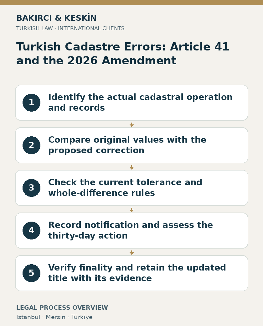
Quick summary
| Legal issue | A Survey Error Changes Your Turkish Parcel: Cadastre Article 41 After the 2026 Amendment |
|---|---|
| Short answer | Current Cadastre Law Article 41 distinguishes technical differences, tolerance and errors after its 2026 amendment. It provides for notification to owners and other right holders and a thirty-day action in the civil court of peace to remove the correction. Its exception from Article 12’s forfeiture period does not eliminate that specific challenge period or turn every ownership dispute into a survey correction. |
| Key legislation | Law No. 3402 — Articles 12, 22, 41; Law No. 4721 — Articles 719, 1020 |
Identify what the cadastral authority has actually changed
A Turkish parcel’s area or coordinates can change through a technical correction without the transaction being a sale or expropriation. The legal basis needs to be identified from the actual document. Cadastre Law No. 3402 Article 41 addresses measurement, boundary delineation, drawing and calculation corrections for immovables whose geometric situation became final through cadastral or later operations. Its current wording incorporates Law No. 7579 Article 16, which took effect on 22 May 2026. Distinguish that effective date from the amending law’s adoption on 7 May 2026 when reviewing older correction records.
Obtain the correction decision, technical explanation, existing and proposed records, and notification document. Identify the block, parcel, owner and other registered right holders. A change to an apartment’s advertised floor area is not automatically this statutory procedure. Nor does every disagreement about a fence establish that the cadastral record contains an Article 41 error. The official operation must be matched to its stated legal basis.
Separate the value appearing on an old title from the boundary and calculation data underlying it. A surface-area figure alone does not explain whether the change concerns a mathematical calculation, a plotted boundary, a coordinate transformation or a different legal operation. The owner’s response should identify the actual discrepancy and its effect on the property instead of assuming that every reduction has the same cause.
The 2026 text distinguishes a difference, tolerance and an error
Article 41 now defines a difference by comparing values such as coordinates and area obtained when the land plan was produced with values recalculated using current technologies. The statutory concept therefore requires comparison between identified sets of measurements or calculations. A newer number should not be treated as self-explanatory merely because it was generated electronically.
The article defines the tolerance limit, or tecviz, by reference to the production method and scale of the plan and the scientifically acceptable difference in measurement and calculation technique between ground boundaries and the relevant measurements and area values. It does not set one universal percentage for every parcel. The applicable technical assessment must explain the method and scale relevant to the particular record.
A difference can fall inside or outside that tolerance. Under the current wording, an error is a situation where the difference exceeds the tolerance limit. These terms should be used consistently in the owner’s report and objection. Calling an unexplained discrepancy an error does not establish that it falls outside tolerance, while describing it as tolerance does not remove the need to identify the underlying comparison.
Both outside-tolerance and inside-tolerance differences are addressed
Article 41 provides that outside-tolerance differences arising from the listed technical operations are corrected on an interested person’s application or by the cadastral directorate on its own initiative. It also states that inside-tolerance differences can be corrected through the same procedure. The distinction between mandatory treatment of the stated outside-tolerance difference and the wording applicable inside tolerance should be preserved.
Where a correction is made, the current article says the entire difference is subject to correction. The assessment should therefore not simply subtract a presumed tolerance amount from the discrepancy and treat only the balance as the legally relevant correction. Obtain the actual calculation and explanation of how the proposed result follows from the official method.
These statutory definitions make older summaries particularly important to check. A review should use the amended text and the current technical material applicable to the operation. The date of an old map does not, by itself, show that its recorded area is legally unchangeable. Equally, the availability of current technology is not a general power to reallocate ownership without a proper legal basis.
Civil Code Article 719 explains the role of the title plan
Civil Code Article 719 identifies the land plan and ground boundary markers as the means of determining immovable boundaries. Where the plan and ground markers do not correspond, the plan boundary is the governing reference under the article. It expressly excepts areas designated as landslide zones by the competent authorities. The applicable situation must be established before using the general rule.
A fence, wall or planted hedge is therefore not automatically conclusive proof of the legal parcel boundary. Preserve evidence of physical markers, but compare them with the authoritative plan and original technical records. A recent private sketch may help explain the dispute without itself replacing the official plan. The report should identify which record each boundary line comes from.
The Article 719 rule does not eliminate the need to investigate an alleged error in the plan itself. Article 41 supplies a technical correction framework within its scope. The task is to identify whether the proposed correction reconstructs the relevant geometric record lawfully or is being used to resolve a different ownership dispute. That question needs both the legal documents and intelligible technical evidence.
Obtain the original data as well as the proposed result
Civil Code Article 1020 permits a person making their interest credible to request access to the relevant registry page and documents or copies through the registry officer. An owner should use the appropriate official route to obtain the records needed for the review. A screenshot from a public parcel viewer is useful for orientation but should not be treated as the complete evidential file.
The working package should connect the original plan, available measurement and calculation records, later amendments and the new correction. Identify versions and dates. Where a historical parcel was divided, combined or renumbered, explain the chain connecting it to the current title. Otherwise the reviewer can inadvertently compare records concerning different legal or geometric objects.
Ask for a clear explanation of the affected values and boundary segments. The technical report should make it possible to understand what changed and why, including the production method and scale relied upon for the tolerance assessment. The owner does not need to invent a competing survey conclusion before seeking the documents, but a substantive challenge must ultimately engage with the actual technical issue.
An owner can request correction, and the directorate can act itself
Article 41 expressly recognises an interested person’s application and an own-initiative correction by the cadastral directorate. The absence of an application signed by the present owner does not therefore establish that the procedure is automatically unauthorised. Identify how the file began and whether the decision concerns the technical matters covered by the article.
An application should identify the parcel and the discrepancy with supporting records. Explain whether the alleged problem concerns measurement, delineation, drawing or calculation. A request stating only that the property should be larger gives the authority little information about the legal and technical basis asserted. Connect the desired correction to the relevant official record instead of treating a purchase expectation as the cadastral standard.
The same discipline applies when opposing a correction initiated by someone else. Identify the portion disputed and the evidence showing why the result or method is challenged. A neighbouring owner’s interest should be distinguished from the cadastral authority’s decision. The review must address the actual correction, its affected rights and the proper parties, rather than assume that every disagreement can be settled by a private boundary declaration.
Owners and other right holders must receive notification
The current first paragraph of Article 41 requires the correction to be notified to the immovable owners and other right holders. Obtain the service records relevant to the applicant’s position. A changed online display or a statement from a neighbour is not automatically the statutory notification document. The method and effective date of service should be checked against the actual file.
For an owner living abroad, promptly establish the address and representation information used for notification. Preserve envelopes, electronic records and any document showing receipt by a representative. The owner’s later discovery of the change and the legally relevant notification can raise different questions. Do not select the more convenient date without examining the service evidence.
Identify other rights affected by the correction, including registered security or limited rights where relevant. The statute is not confined to the current owner’s name alone. The working chronology should show who was notified, when and of which correction. This information helps determine finality and the procedural position without assuming that a single receipt resolves every interested person’s rights.
The statutory challenge is a thirty-day civil-court-of-peace action
Article 41 states that the correction becomes final if no action to remove it is brought in the civil court of peace within thirty days from notification. The provision identifies a court action and its starting event. A private demand to the neighbour or a general complaint letter should not automatically be treated as the action described by the statute.
The challenge should identify the correction sought to be removed and the specific objection to its technical or legal basis. Assemble the current title, correction record, plans, technical material and notification evidence. Where expert assessment is necessary, the issues should be framed clearly so that the underlying measurements, method and effect on the parcel can be examined.
Do not assume that ongoing correspondence with the directorate suspends or restarts the thirty-day period. The effect of any procedural step must be assessed under the applicable rules and actual circumstances. An owner abroad should provide the served decision immediately, even if a complete translation or private technical report is still being prepared. The filing question and the further evidential work must be managed together.
Article 41 expressly excludes the Article 12 forfeiture period
Article 12 contains the ten-year bar on challenges based on pre-cadastre legal grounds after the relevant cadastral records become final. Article 41 expressly states that the forfeiture period in Article 12 is not required when applying Article 41. A qualifying technical correction should therefore not be dismissed solely because more than ten years have passed since the original cadastral work.
That exception is tied to application of Article 41. It does not convert every old ownership grievance into a timeless technical-correction claim. Identify whether the complaint concerns the geometry covered by the article or an asserted pre-cadastre ownership entitlement. The substance of the demand matters more than placing the words survey error on the cover of the application.
The exception also should not be confused with the thirty-day challenge to an actual correction. The age of the original cadastral record and the period for contesting the newly notified correction address different stages. Keep both dates in the chronology and state which rule is being applied. A general assertion that technical errors have no deadline can obscure the specific action period in Article 41 itself.
Check whether the file instead concerns cadastral-map renewal
Article 22 generally prohibits a second cadastre of places already subjected to the specified cadastral procedures, while setting out exceptions. One exception concerns redrawing technically inadequate, deficient or inaccurate maps and making necessary registry corrections under Article 22(2)(a). That area-based process has its own statutory framework. A document referring to it should not automatically be analysed solely as an individual Article 41 correction.
Read the heading, legal basis, scope and notification or announcement in the actual file. Identify whether one parcel is being corrected or a wider mapping operation is being undertaken. A technical surveyor can explain the records, while the legal review determines the applicable procedural route. Mixing the two statutes can lead to an incorrect account of finality, notice or the proceeding required.
Other changes also require separation. Zoning readjustment, expropriation, a judicial title correction and a sale of part of the land are not simply measurement corrections. The site’s foreign ownership guide explains why title and planning checks operate together. The owner should identify the legal operation before deciding what a changed area figure means.
Keep cadastral correction separate from a claim against the seller
A buyer’s contractual expectation about land area raises a separate question from the accuracy of the official cadastral record. The seller’s description, official title and agreed contractual terms may need their own examination. A successful Article 41 challenge does not automatically determine a refund, while an unsuccessful technical objection does not itself decide every contractual issue between buyer and seller.
Preserve the sale documents, marketing materials relied upon, valuation and the title available at completion. Record when the discrepancy became known and what the parties said about it. The legal reviewer can then identify the actual contractual basis without rewriting the cadastral issue as an assumed promise by the State or the seller about every measurement.
The site’s title-record guide addresses obtaining authoritative ownership information. For a survey correction, retain both the historical record and the final updated record rather than replace the old file silently. The difference between them is part of the evidence needed to understand the transaction and any separate claim.
Give the overseas owner a result that can be checked
The final review should explain the original figure, proposed figure, source records, technical reason, tolerance analysis, notice date and procedural result. It should state whether an action was filed and whether the correction became final. A report saying only that the land became smaller leaves the owner unable to assess what happened or which rights remain relevant.
Keep the technical and legal conclusions distinguishable. A surveyor’s calculation can support a factual position without deciding ownership, while a legal opinion cannot replace measurements it has not verified. Record unresolved technical questions accurately and obtain the appropriate evidence. This is more useful than presenting a precise new area without explaining its source or legal status.
The current Article 41 framework provides a defined route for technical corrections and a defined opportunity to challenge the result. An owner abroad should concentrate on obtaining the actual records, identifying the statutory operation and responding to the notified correction within the applicable process. The corrected or preserved title should then be checked against the final decision and retained with the complete file.
Frequently asked questions
What did the 2026 amendment change in Article 41?
The current text defines difference, tolerance and error and addresses correction of outside-tolerance and inside-tolerance differences, including correction of the whole difference when the procedure is used.
Is every changed area figure legally an error?
No. The statute distinguishes differences inside and outside the applicable tolerance. The technical method, scale and records must establish the classification.
Does Article 41 set a universal tolerance percentage?
No universal percentage appears in the article. Its definition refers to scientifically acceptable measurement and calculation differences according to the plan’s production method and scale.
Can the cadastral directorate act without my application?
Article 41 permits own-initiative action as well as an interested person’s application within its specified scope. Notification and challenge rights still need review.
Who receives notification of the correction?
The current Article 41 refers to immovable owners and other right holders. Obtain the actual notification records for the affected rights.
How long do I have to challenge the correction?
Article 41 provides thirty days from notification for an action to remove the correction in the civil court of peace. Do not substitute an informal complaint for the required proceeding.
Does the ten-year cadastral bar prevent every technical correction?
Article 41 expressly excludes the Article 12 forfeiture period for its application. That does not convert a different ownership claim into a technical correction.
Does my fence conclusively establish the boundary?
Article 719 compares the title plan and ground markers and ordinarily gives the plan boundary priority, with its stated landslide-zone exception. The actual plan and any alleged error must be examined.
Is Article 22 map renewal the same procedure?
No. Article 22 contains a distinct framework for the specified wider mapping operations. Read the actual legal basis before selecting the challenge route.
Does a cadastral correction automatically create a refund claim against the seller?
No. Contractual area representations and remedies require separate examination of the sale agreement and applicable law. Preserve both the cadastral and transaction records.
Official legal sources
Recorded primary-source check dates: 26 October 2026. The official Turkish legislation controls. A new publication-date check is still required.
Contact information
Do not include confidential documents or identity numbers in an initial message. An enquiry does not establish representation or suspend any legal deadline.
Istanbul and Mersin contact details
Bakırcı & Keskin Law Office is Mersin-based. Turkish matters are handled under the applicable jurisdiction and agreed mandate. The competent court and the scope of representation are assessed for each matter.
Istanbul — Polaris Plaza
Maslak Ahi Evran Caddesi, Polaris Plaza No:21, Floor 9, 34475 Sarıyer/İstanbul, Türkiye.Mersin — Profit İş Merkezi
İhsaniye Mahallesi, 4903. Sokak, Profit İş Merkezi No:23, Floor 3, Office 14, 33070 Akdeniz/Mersin, Türkiye.+90 552 224 43 66 · Contact details in English. An enquiry does not establish representation or suspend a legal deadline.
Istanbul Office – Polaris Plaza, Maslak / Sarıyer
Bakırcı & Keskin Hukuk Bürosu
Maslak Ahi Evran Caddesi, Polaris Plaza No:21, Kat:9, 34475 Sarıyer/İstanbul
Our physical offices in Istanbul and Mersin coordinate matters throughout Turkey, subject to jurisdiction and the local steps required for each case. Please specify your preferred office when arranging an in-person appointment.
Open the Istanbul office on Google Maps · Contact and appointments
Contact regarding a legal matter
In your first message, you may briefly state the subject, your country or city, and any relevant notification or recent procedural date. Please do not send identity numbers, medical data, or personal documents. Messaging alone does not constitute legal advice or create a lawyer–client relationship.
Discover more from Bakırcı & Keskin Hukuk Bürosu
Subscribe to get the latest posts sent to your email.